 I am teaching a seminar this semester at the University of Colorado, Denver, College of Architecture and Planning on Sustainable Urbanism. What is that you might ask ... as do I! But we are trying to find out and questioning the terms and approaches in the process. For one thing, the class is exploring the issue of scale and sustainability: at what scale can different
  aspects of the city be optimized to achieve the best results. While I am teaching all the elements that contribute to sustainable places, we are also exploring what are the best metrics to more rigorously assess a neighborhood's performance.
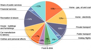
To that end, we are using carbon footprint as
 one way to look at a neighborhood. What has been interesting is that there is a)no standard way to do this, b)it only tells part of the story, and c)there are so many unique qualities to a neighborhood that this metric can be mis-leading. But the neighborhood size is interesting since it is the lens through which we best understand our individual experience of the city and is of a scale that we can have an impact that is significant. So we forge ahead ... and try to invent a methodology. One group is developing an actual calculator - add data into a spreadheet and BLAM! a number comes out.
Each group is taking a specific neighborhood and looking at what sustainability means for it: from LODO to Elyria-Swansea, a new and old TOD and the Gates Redevelopment. They are then applying the calculator to understand what the Baseline Carbon Footprint is and then how it can be changed (Lowered) to meet that of Manhattan, NYC, the lowest in the country. How can Denver beat Manhattan!!
Stay tuned. Much more to come on this!!
